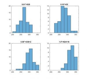
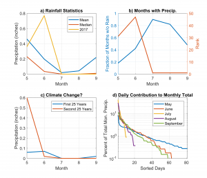
Matt Igel

Convective Atmosphere Group

Page 5 of 7

Hurricanes Focus Our Attention

There is nothing I can say scientifically or socially about hurricanes that hasn’t already been said in the past two weeks.  So, I won’t try.  Many colleagues are much better able to discuss individual hurricanes than I am.  While their destructive force can bring and, recently, has brought incomprehensible misery to those living in their path, hurricanes stands out starkly as almost unbelievable.  They are fundamentally so different than anything else in meteorology.  So much has to go just right in order for a hurricane to form that I think it’s easy to take their existence for granted.  Hurricanes need the perfect combination of moisture (which the tropics have plenty of), initial convergence (which, again, the tropics has plenty of), and spin from Earth (yeah, that doesn’t ever change but only occurs in a narrow band near the equator).  Yet, hurricanes are remarkably infrequent, even if at the present, they don’t feel that way.  Hurricanes are simply a marvel of nature.  The strongest often form nearly perfectly circular clouds that stretch for more than 500 miles and winds that howl at over 150mph interrupted only at their center by cloud-free quiescent air in their stadium-like eye.  Hurricanes are amazingly simple: they can be described well with just a few equations derived from simple mechanical physics.  Yet, hurricanes are amazingly complex: the world’s best computer models still fail to simulate their growth and decay with the desired fidelity.  Hurricanes are often symmetric yet made up of turbulent, chaotic, transient flows.  They’re almost unbelievable.


I wish all my friends and colleagues back in Miami the best of luck this weekend.

Plenty of Physics Left to Phind

Meteorology, atmospheric science, and climate system science is each classified as an applied science.  That means that these fields are concerned, as much as anything, with practical, real world problems –making better weather forecasts of hurricane Gert or of cloudiness during the next solar eclipse, or making more accurate predictions of future climate states.  These are important and impactful concerns.  But sometimes I think we tend to forget that there is still plenty of new physics to be found in the atmosphere.  I love these kinds of problems; I have several papers in the works that might be considered pure (by which, ironically, i mean, applied) physics.  I was reminded that there are still fundamental aspects of the atmospheric system which we do not understand that are rooted in simple physics by this interesting paper on the momentum budget of a mixture of air and condensing/evaporating rain drops — something most of us who think about clouds on a daily basis have never really considered.  We’ve been studying atmospheric physics for over 100 years and yet there is still plenty we don’t understand.  This is largely because we fail to translate physics we learned about in college to the atmosphere completely, not because the atmosphere is such a special place that it presents particularly unique physics.

My 3rd Gordon Conference

I wanted to offer a couple of thoughts from my third Gordon Conference on Radiation and Climate.  First off, I love the format.  At a Gordon Conference, ~150 scientists are plopped down in a small (often, New England) college setting with nothing to do but talk about science 24 hours a day.  It’s a fantastic opportunity for students, postdocs, and new and ‘experienced’ faculty to sit down and really discuss issues.  Formal talks are 40 minutes and discussion lasts 20 minutes.  It really allows for a deep-dive into complex topics.  More than any other conference I attend, I always feel like I come away with a full appreciation for the major questions in clouds, radiation, and climate and what a lot of really smart people are doing to address them.  I also come away motivated to pursue new questions and confident that we’re making progress on important issues.  Second, I wanted to compliment the organizers of this particular GRC especially.  It was very well thought out.  The sessions and speakers were very well chosen.  The point was repeatedly and well made that we need combined solutions to measurement and modeling problems.  The time is past that these fields could be independent.  I’ll see everybody again in two years.

Also, special thanks to those who offered Thursday night’s special surprise entertainment!

The Precipitation Pickup. Part 2.

If there is a ‘part 1’, there was probably going to be a ‘part 2’, right?  In the second paper up on my Publications page about the tropical precipitation pickup, I break apart the standard total column humidity metric.  I show that most clouds don’t actually care what the column humidity is.  In some senses that is not at all surprising, but in other senses that is.  I separate the column moisture into two parts.  Armed with these two new measurements of moisture, we can describe why the pickup value occurs where it does.  The other interesting suggestion in this paper is that of a discrete set of rules cloudy atmospheres seem to follow.  The moisture state of the convective tropical moisture is transient.  At long enough time scales, the atmosphere is always moving toward the pickup value (either from below or above it).  Local layers are also always trying to limit their local humidity.  If you combine these two rules, you can compactly describe the evolution of the tropical convective atmosphere.  Pretty cool.

The Precipitation Pickup. Part 1.

It’s been a long time coming, but my first set of papers on the tropical “precipitation pickup” are finally in press.  You can find a link to both papers on the “Publications” tab.  In Part I, I spend ~6000 words discussing the ways in which clouds and precipitation processes depend on column humidity.  It turns out that clouds don’t always care about column humidity.  This makes sense for certain clouds like shallow/congestus convective clouds or for deep stratiform clouds that don’t span the troposphere.  Yet, it has taken us nearly 15 years to actually put that down on paper.  I won’t summarize the paper.  If you want a quick summary, read the abstract.  But, I will mention a few things that didn’t get published in that paper that I think are interesting.  The first is that the precipitation pickup does not appear to be the result of a systematic change in stability.  The tropical atmosphere is broadly unstable almost everywhere.  Instability increases with column moisture, but it does not change state near the pickup in my simulations.  The second is that nobody I have had a conversation with has agreed on precisely what the “scale invariance” of some of the precipitation statistics really means.  If you, oh wise internet reader, have a suggestion, get in touch with me.

Bill Rossow’s Retirement

I was lucky enough to present some ongoing work at Bill Rossow’s retirement symposium earlier this week.  It was a great chance to give an incredibly influential colleague (if I might be bold enough to call myself a colleague) a fun send off.  Bill was a student of Carl Sagan’s at Cornell and got his start studying the clouds of Venus, Mars, and Jupiter.  And, this is the thing that impressed me the most about Bill — his academic interests are truly eclectic.  My feeling is that more of us should study a variety of things.  It helps us makes connections that we couldn’t before.  I think Bill’s work, especially his early work, bears the imprint of someone who was thinking about several different problems.  Bill also taught me another valuable lesson: suspenders make the man.  Happy retirement, Bill.

CA Air Quality

One of the great environmental and human-health success stories of the past 50 years has been the improving quality of America’s air.  Acid rain is less acidic than it was a generation ago and particles harmful to human health are less concentrated in our air.  But that is not to say that air quality is especially good in all parts of the country, all of the time.  The picture below was taken on my way home to Davis (well, the Sacramento airport) from a conference in LA.  The picture is taken looking east at the southern end of the Central Valley as the sun was setting.  This particular setup, with the sun behind me and my looking far off to the east, results in a particularly hazy looking picture.  If you’re interested to know why, please take ATM 128.  But, getting back to my point, individual locations in the US are still susceptible to conditions that result in poor air quality.  Unfortunately, the Central Valley is one of those places.

(Disclaimer: I do not endorse Southwest or any other particular airline)

Weather Inspires Poetry

I am a fan of saying that science should be fun.  Apparently at least one of the forecasters in the Seattle NWS office feels the same way.  At 2:30am on Sunday morning, this particular forecaster wrote a discussion that will likely become one of the more famous ever.  Enjoy.  Also, thanks to a former classmate, Angela Rowe, now at UW for pointing this out.


Your Phone is about to Do Something Useful for a Change

Since the first indications came out several years ago that we might be able to use the attenuation of cell phone signals to measure precipitation near the surface at unprecedented resolution, I have been anxiously waiting further development of the idea.  This week Nature (http://www.nature.com/news/mobile-phone-signals-bolster-street-level-rain-forecasts-1.21799) published a short report on the progress of one company trying to commercialize the technology.  Particulars of this company aside, the fact that the use of cell phone signals to measure precipitation is mature enough that someone is working to sell the data is really exciting.  For most folks, high resolution precipitation data will mean better, hyper local forecasting in locations with lots of active cell phone users.  That’s exciting, but ultimately a little fleeting.  I see the real promise of this technology being that it will contribute significantly to our understanding of clouds and precipitation at very small scales.  A super high resolution tool has been missing from our research toolbox for too long.  Better understanding of clouds will lead to better forecasts everywhere.  I can’t wait.

Spring Training

So, it’s every baseball fan’s favorite time of year again.  No, not the World Series, not the All-Star game, but Spring Training.  It’s a special time in the baseball season when guys wearing number 97 run their hardest to catch a meaningless fly ball hit by Albert Pujols in a 10-2 blowout in an earnest effort to make the Major League team…or at the very least, to have their name associated in some small way with a future Hall of Famer.  Well, OK, maybe it’s not every baseball fan’s favorite time of year.  But, it’s definitely one of mine.

Anyway.  I’ve decided recently that Spring Training is a fantastic metaphor for a university course.  For veterans (the professors) who are already on the team, Spring Training (the course) is a chance to relearn the basics — be they executing a double play or doing integration by parts for the first time in a year.  It can be a source of entertainment and a welcome return to a routine in an otherwise chaotic calendar.  For the prospects (the students) wearing number 97, games (tests) and workouts (homeworks) are a great opportunity to learn something new (duh), see how things work at game speed in the Show (“Let’s derive the vorticity equation from first principles”), impress the front office guys (maybe, future employers? ), and catch a lazy fly ball hit by one of the veterans (keeping track of negative signs while deriving things on a white board is hard…).  So, here’s to every baseball fan’s favorite time of year, Spring Semester.

« Older posts Newer posts »

© 2024 Matt Igel

Theme by Anders NorenUp ↑