Convective Atmosphere Group

Month: January 2017

California Gets High

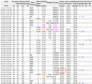
We often hear about meteorological records being broken.  That is especially true for high temperatures, which is a symptom of global warming, and record rainfalls, which some argue is also symptomatic of global warming but which I would argue is simply the result of the oddity of the statistical distribution of precipitation…but that isn’t the point of this post.  The point is that those of us in the central valley approached another type of all-time record this weekend without much fanfare .  We approached the all-time high (atmospheric) pressure record at the Sacramento Airport this weekend.  On Saturday at 9:53am PST, the sea-level pressure recorded was a whopping 1036.6 mb.  That’s seriously high.  The all-time January record is barely higher at 1037.6 mb.  The difference between yesterday’s pressure and Earth’s standard pressure of 1013 mb is the same as the difference between the standard pressure on Earth and some tropical storms (but in the opposite direction)!

It’s All About Optical Thickness

I was flipping through my (digital) stack of papers and articles to read this afternoon when I stumbled upon a commentary article I’ve had sitting around for a few months.  Tropical anvil clouds and climate sensitivity reviews in an easy to read way the basic state of our knowledge regarding the radiative heating of clouds in the current climate.  The point I found most interesting is one buried toward the end.  The author argues that the new challenge facing cloud-climate types is to determine a general physical law governing the relative distribution of optically thick clouds (which will cool the climate all else being equal) and optically thin clouds (that will warm the climate all else being equal).  This is precisely the kind of work we do here in the Convective Atmosphere Group.  Why are some clouds tall and narrow?  Why are some short and wide?  Increasingly, climate predictions will depend on answering those kinds of fundamental questions.  It’s all about that optical thickness.

Also, I am now an official CocoRaH’s observer: “0.7 miles NNE of Davis”.  You should join too.

More Weather Along the Capitol Corridor

Along with all the rain and the absolutely incredible snow totals in the Sierra, NWS confirmed yesterday the occurrence of an EF0 tornado just south of Sacramento on Jan. 10.  There was very little damage reported, and this was nothing like the tornadoes that occur in much of the country, but it does serve as a reminder that tornadoes can occur across the United States.


Another Wet Weekend in CA

It has been an incredibly wet start to the year here in Northern California, and we are in store for another incredible few days through early next week.  Snow reports from Sierra towns and ski resorts since last weekend have been impressive.  I can personally confirm that some of the terrain at Squaw Valley received at least 3′ of fresh snow in the 48 hour period ending on the morning of the 5th.   Local reports here in the central valley exceeded an inch for each of 3 consecutive days (Thanks, CoCoRaHS) and one spot in the Sierra reported 60″ of new snow over the same period.  In addition to all that moisture, it looks like more is on the way.  NWS is forecasting a 70% chance of at least an additional 30″ of snow (their highest category) in the Sierra and another 2″ of rain for here in Davis.  Stay dry, my friends.

© 2024 Matt Igel

Theme by Anders NorenUp ↑